
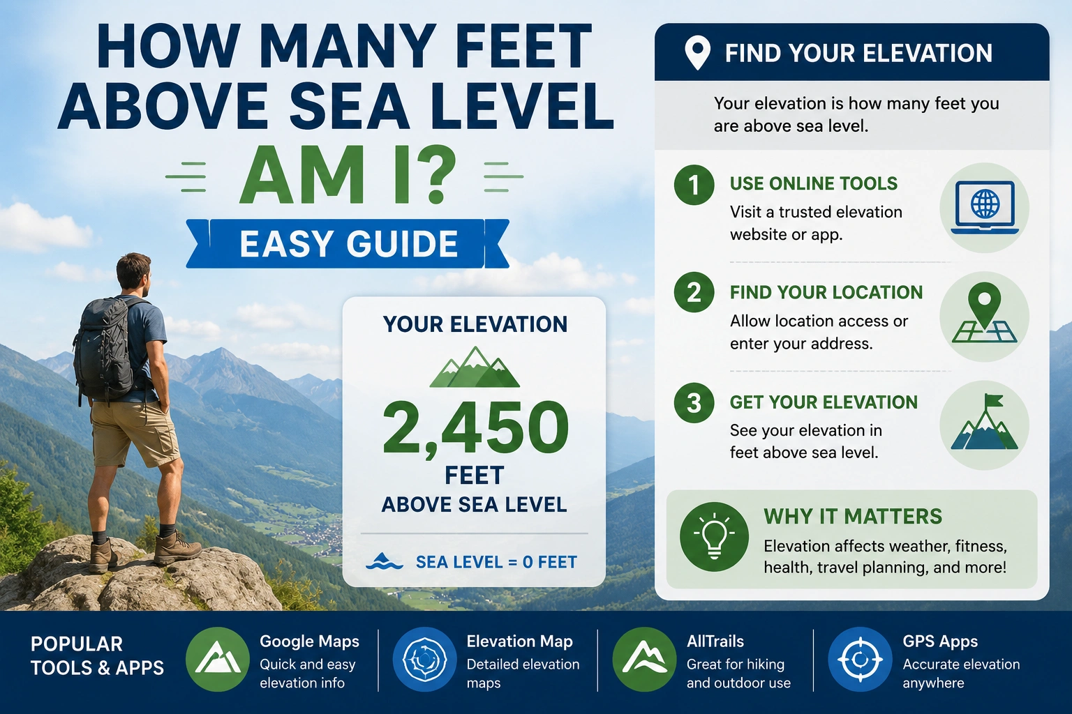
If you have ever traveled, hiked, moved to a new city, or checked weather conditions, you may have wondered: how many feet above sea level am I? This measurement is called your elevation or altitude.
Elevation refers to how high a location sits compared to sea level, which serves as the standard reference point for measuring land height worldwide.
Your elevation could range from:
- 0 feet near the ocean
- Thousands of feet in mountainous areas
For example:
1,000 feet above sea level
Means the location sits 1,000 feet higher than average sea level.
This guide explains how elevation works, how to find your current elevation, why altitude matters, and common tools used for accurate measurements.
Understanding Elevation and Sea Level
Before finding your elevation, it helps to understand basic geographic terms.
What Is Sea Level?
Sea level is the average level of the ocean’s surface.
It acts as the worldwide reference point for measuring elevation.
Locations can be:
- Above sea level
- At sea level
- Below sea level
What Is Elevation?
Elevation is the height of a location compared to sea level.
It is usually measured in:
- Feet
- Meters
For example:
500 feet above sea level
Means the area is 500 feet higher than ocean level.
Why Elevation Matters
Elevation affects many aspects of daily life, including:
- Weather
- Air pressure
- Health
- Construction
- Hiking difficulty
- Flood risks
Higher elevations usually have:
- Cooler temperatures
- Thinner air
- Lower oxygen levels
How Many Feet Above Sea Level Am I?
Your exact elevation depends entirely on your location.
For example:
| Location Type | Typical Elevation |
|---|---|
| Beach town | 0–50 feet |
| Flat plains | 500–1,500 feet |
| Mountain towns | 5,000+ feet |
| High mountains | 10,000+ feet |
Cities around the world vary greatly in elevation.
How Elevation Is Measured
Several technologies measure elevation accurately.
GPS Technology
Most smartphones use GPS satellites to estimate elevation.
GPS apps can display:
- Current altitude
- Terrain elevation
- Hiking elevation gain
Topographic Maps
Topographic maps use contour lines to show land elevation.
These maps help hikers and engineers understand terrain changes.
Survey Measurements
Professional land surveyors use advanced equipment for precise elevation data.
Survey measurements are important for:
- Construction
- Property development
- Road building
How to Find Your Elevation
Finding your elevation today is easier than ever.
Use Smartphone GPS Apps
Many phones include built-in compass or map apps showing elevation.
Popular elevation apps provide:
- Real-time altitude
- Hiking tracking
- Terrain maps
Online Elevation Tools
Many websites allow you to enter your address and view elevation instantly.
These tools use:
- Satellite data
- Geographic surveys
- Digital terrain models
GPS Devices
Outdoor GPS units provide more accurate readings for:
- Hiking
- Camping
- Mountaineering
Map Services
Digital maps often include terrain and elevation layers.
These help users visualize height differences.
Elevation Examples Around the World
Elevation varies dramatically worldwide.
Coastal Cities
Cities near oceans usually sit close to sea level.
Examples include:
- Miami
- Amsterdam
- Venice
Mountain Towns
Mountain communities often exceed:
5,000 feet above sea level
These areas experience cooler climates and lower oxygen levels.
High-Altitude Regions
Some mountainous areas exceed:
10,000 feet
At these elevations, altitude sickness becomes more common.
Elevation Conversion Formula
Elevation measurements may use feet or meters.
Feet to Meters
Meters=Feet×0.3048
Meters to Feet
Feet=Meters×3.281
These formulas help travelers convert altitude units internationally.
Why Elevation Matters
Elevation affects many industries and activities.
Weather
Higher elevations are generally cooler.
Temperature often drops as elevation increases.
Health
Very high elevations may cause:
- Altitude sickness
- Breathing difficulties
- Fatigue
Construction
Builders use elevation data for:
- Drainage planning
- Flood prevention
- Foundation design
Hiking and Travel
Hikers monitor elevation for:
- Difficulty planning
- Safety
- Oxygen management
Common Elevation Measurement Mistakes
Incorrect readings are common.
Confusing Altitude and Height
Altitude usually refers to aircraft height, while elevation describes ground height.
However, the terms are often used interchangeably.
GPS Inaccuracies
Phone GPS readings can vary because of:
- Signal interference
- Weather conditions
- Satellite positioning
Ignoring Terrain Variation
Elevation may change dramatically within short distances in mountainous areas.
Expert Tips for Accurate Elevation Readings
Professionals recommend several best practices.
Use Multiple Sources
Compare readings from:
- GPS apps
- Maps
- Online elevation tools
Check Terrain Maps
Topographic maps provide more reliable terrain detail.
Understand GPS Limitations
Consumer devices are helpful but not always perfectly accurate.
Real-World Example
Suppose you live in a city with an elevation of:
1,200 feet above sea level
This means your location sits:
- 1,200 feet higher than average ocean level
Your local climate may be cooler than nearby coastal areas.
FAQs
1. What does above sea level mean?
It means the height of a location compared to average ocean level.
2. How can I check my elevation?
You can use GPS apps, online elevation tools, or topographic maps.
3. Is elevation the same as altitude?
They are similar, but elevation usually refers to land height while altitude often refers to aircraft height.
4. Why does elevation affect weather?
Higher elevations have lower air pressure and cooler temperatures.
5. Are smartphone elevation readings accurate?
They are usually reasonably accurate but may vary slightly depending on GPS conditions.
Conclusion
Understanding how many feet above sea level am I helps with travel, hiking, construction, weather awareness, and health planning. Elevation measures how high a location sits relative to sea level, such as:
1,000 feet above sea level
Modern GPS tools, online maps, and elevation apps make it easy to find accurate altitude information almost anywhere in the world. Whether you are hiking mountains or checking your home’s elevation, understanding sea level measurements provides valuable geographic insight.
Discover More Articles
How Many CM Is 5 Feet? Easy Height Conversion